Panchkula district has a sub tropical continental monsoon climate having, hot summers, cool winters, good monsoon rainfall. It has great variation in temperature (-1 °C to 43 °C). Sometimes winter frost occurs during December and January. The district also receives winter rains from the western disturbance. The rainfall is mostly received in the monsoon. Morni hills constitute the highest point of the district as well as of Haryana. The Ghaggar is the only perennial river, which is very shallow outside of the monsoons.
Generally the slope of the district is from north east to south west and in this direction, most of the rivers/streams rainfed torrents flow down and spread much gravel and pebbles in their beds. Only the Sirsa river, in Kalka Tehsil, flows towards northwest. The soils in the district are mainly light loam.
The underground water in the district is generally fresh and suitable for domestic and irrigation purposes. The underground water level is generally high in the southern parts and low in north and northeast which is hilly tract. The district lies in the Himalayas boundary fault zones and earthquakes of moderate to high intensity have occurred in the past.
Hill stations to visit near Panchkula.
HOW TO REACH
By Air:-
The town of Panchkula is situated in a planned position, so as to nulify the question how to reach Panchkula. This beautiful city is easily accessible from all the major cities and towns. Panchkula can be accessed through airways via the airport at Chandigarh. There are a number of flights which connect Chandigarh city with other major parts of the country.
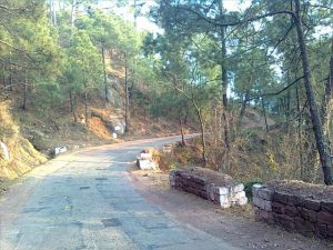
By Road:-
Road is considered as best option to reach the town of Panchkula. It is one of the best ways to reach the city. Kalka (19 km), Ambala (46 km) and Chandigarh (11 km) are the few cities that can be reached easily via road.
By Train:-
One can easily reach the destination via railways as there are a number of trains available which offer direct services to the district.
WHAT TO SEE
Kalka :–
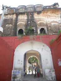
 Kalka is a city and a municipal committee in Panchkula district in the Indian state of Haryana. It is on the NH 22 on way from Chandigarh to Shimla, and is the terminus of the Kalka-Shimla Railway.The town is situated on the foothills of Himalayas and is an entry point to Himachal Pradesh – The land of Gods. The name of the town is derived from the Goddess Kali and an ancient temple of the Goddess is located here. The temple has thousands of pilgrims turning up each year with a particularly heavy footfall during the Hindu festival of Navratri. In 1988 an ancient temple of Balaji (childhood incarnition of Hindu god Hanuman) was excavated in village “Bhairo ki Ser” on one of the hills overlooking the town.The temple is managed by Shri Amardass Ratan who is the “mahant” of the temple…it is slowly developing into a major pilgrim attraction.
Pinjore :–
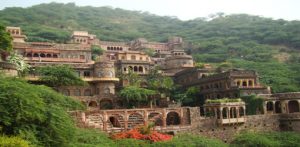 As of 2001[update] India census[1], Pinjore had a population of 25,498. Males constitute 54% of the population and females 46%. Pinjore has an average literacy rate of 76%, higher than the national average of 59.5%: male literacy is 80%, and female literacy is 71%. In Pinjore, 13% of the population is under 6 years of age.
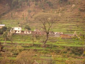
Morni :–
 Morni is a tourist place in Morni Hills in Panchkula district of Haryana in India. Morni Hills are the offshoots of Shivalik range of the Himalayas, which run in two parallel ranges. The village of Morni (Bhoj Jabial) lies on the mountainside, at 1220 meters above mean sea level. Traditions assign the name of Morni to a Queen who is believed to have ruled this area. Among the spurs of hills, lie two lakes, the larger is about 550 meters long and 460 meters broad and the other about 365 meters either way. A hill divides the two lakes but there is some Hidden channel, as the level of two lakes remains the same. The people look upon the lakes as sacred. There is an old fort, which is now in ruins. The hills are covered by pine trees. The climate is salubrious and the area is suitable for trekking.
Nahan :–
 A well-laid out picturesque town, Nahan is situated on a hill top in the Shiwalik Hills, overlooking green hills. Traditionally, saints and princes are linked with the origin of Nahan. The city was founded as a capital by Raja Karan Prakash in 1621. Another version recalls a saint who lived with a companion named Nahar on the site where the Nahan palace now stands. “Nahar” means Don’t kill and the town probably takes its name from an incident when a king was trying to kill a lion and the saint said Nahar, that is do not kill it. The name of the saint was Baba Banwari Das.
Dagshai :–
 Built by the British as a sanatorium for T.B patients, it has a British era graveyard overlooking a valley. It is on the same height as Lawrence School Sanawar near Kasauli, and is a short drive from Dharampur on the Chandigarh Simla highway. It is some 65 kilometers from Chandigarh. Unlike Kasauli it is to the right of the highway while driving towards Simla. There are two roads up, both steep. And after snow , snow chains are a must to drive up to Dagshai or getting down from it. There is an army unit stationed there, a residential only Army Public School, Dagshai and a private school called Dagshai Public School.
Raipur Rani:–
 Raipur Rani was ruled till Indian Independence by descendants of the founder who were titled Rao Sahib. Founded in 1420 by a Chauhan Rajput named Rao Rai Singh, it is located on the Chandigarh- Nahan-Paonta Sahib-Dehradun Highway. At a distance of 11 km from the town, the sacrosanct Temple Complex of Sharda Mata is located. Situated on the border of Harayana and Himachal Pradesh, this temple is dedicated to Maa Saraswati, Goddess of education.
Fun City:-
 Fun City is an amusement and water park that offers a combination of adventurous rides. Spread over an area of 43 acres, it is the largest amusement and water park in North India. The park offers hi-tech hydraulic rides, in addition to a wave pool, three landing pools, lazy river, splash pool, typhoon tunnel and even an Aqua Disco.
Nada sahib:-
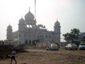 Nada Sahib is the spot where Guru Gobind Singh halted along with his entourage while travelling from Paonta Sahib to Anandpur Sahib after the Battle of Bhangani in 1688. Situated in Panchkula on the bank of Ghaggar River, the gurudwara lies at the foot of Sivalik Hills. After having fought the battle with Mughals, Guru Gobind Singh was on his way back, when he halted at the site for a brief time.
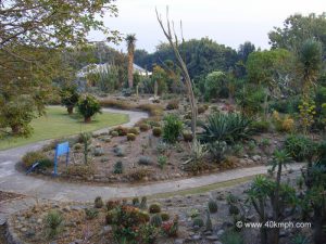
Cactus Garden:-
 Cactus Garden has a collection of Indian succulents, which is considered to be the largest in the world. Designed by Dr J.S. Sarkaria, it is Asia’s largest outdoor landscaped cacti and succulents garden. Chief architect of the garden, Dr J.S. Sarkaria donated a large collection of cacti and succulent plants. The garden was established with the aim to preserve and conserve this endangered species.
Mansa Devi Temple:-
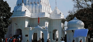 Mansa Devi Temple, located on the foothills of Shivalik Range, is an epitome of age old tradition of ‘Shakti’ worship in northern India. Symbol of Himalayan culture and faith, the temple is dedicated to goddess Mansa Devi, a form of Shakti. About 200 years old, the temple complex contains two temples. Out of the two temples, main temple is dedicated to Mansa.
SHOPPING:-
Panchkula, one is spoilt for choices when it comes to shopping. Depending on one’s taste and budget, one can opt for shopping in upscale malls or street market, for Panchkula has best of both the worlds.
FOOD:-
One can find restaurants offering North Indian, south Indian and Mughlai cuisines part from regular fast food and jinx food outlets such as dominos, pizza hut, mc donalds etc. Even if not willing to go for a complete meal, one can gorge on snacks along with a cup of coffee at various coffee shops spread across the city.